GcmWin 3.1.0 is out
Posted: December 27th, 2009 under Hamradio, Software.

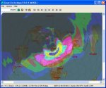
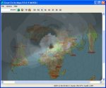
 Exciting stuff is happening with this program. I haven't used it in a while, but just a few days ago I checked up on what was going with the program development. For those of you who haven't heard about this program, it's a free Windows program for plotting great circle maps from your location, locator maps, grayline and realtime propagation maps. Read the changelog below:
New version 3.1.0 – 26 December 2009
- Bugfixes
- Real time for propagation now works
- Time got its own tab now. Sets time for both grayline and voacap.
New version 3.0.9 – 5 December 2009
- Vocap now works in the western and southern hemisphere.
- Icearea and Voaarea implemented
- You can set transmitter power and gain in the receive and transmit antennas
- You can plot color or b/w for the propagation layer
- In the toolbar you can change band for the propagation layer.
- The picture you see – is the picture that is saved. (changed from previous version)
- The "real" time display for the propagation is not redrawing itself. You have to manually click on create map or change band!
- Since the propagation is made on an hourly basis – 9:30 plotted as 09:00 hours and 09:31 plotted as 10:00…
- The propagation forecast can only be made every hour (limitation of voacap)
- If you have used version 3.0.8, please change directory for voacap to "c:\itshfbc" NOT "c:\itshfbc\areadata"
Changes from 3.0.7 to 3.0.8 – 15 November 2009
- Some bugfixes from 3.0.7
- Interacts with Voacap (get Voacap here: http://www.voacap.com/ ) This part is buggy and not fully functional, but you are welcome to try it out!
- More precise sun position (formulas from here: http://stjarnhimlen.se/comp/ppcomp.html#5 )
Changes from 3.0.6 to 3.0.7…
- A greyline function is implemented. Choose between realtime map that updates every minute and a one shot map.
- Prefix format has changed. Look at the PrefixNew.dat (Thanks to SM5FQQ, Jan who supplied the updated file!)
-
The line thickness for the compass can be changed!
Changes from 3.0.5 to 3.0.6…
- Now you can plot two different locator files with different colour, hatching and transparency (one for worked and one for confirmed squares..)
-
Plotting now accepts 4 character locators (JP83 or JP83PE are plotted the same way)
Other features..
- Borders, coastlines, rivers, lakes can be added
- Text and lines can be partly transparent and in the colour of your choice.
- Freeware
Download the program here.
Comments: No comment yet, you could be the first
